Caucasus round 4: Exploring Armenia
My first experience of UBES was back in early 2017, when a neighbour in my first-year halls (Rory Bryson) told me about an awesome society he was part of, where there are weekend trips to the mountains to go hiking. I had somehow not come across the society during the mayhem of Freshers’ Week, and by this point it was quite late in the academic year. There were not too many weekend trips left, but on the horizon were some summer expeditions, so I figured why not sign up? I got to know my companions at a couple of preparation sessions, and then we were off to Georgia for three weeks of backpacking! This was very much a trial by fire for getting into the society, but I loved every minute of it, and since then, the country of Georgia and the Caucasus Mountains have held a special place in my heart.
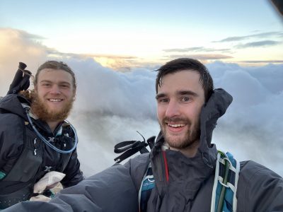
Fast forward seven years to summer 2024 (how time flies!), and it’s time to return to that area of the world. This time it’s just me and Cat Easdon (the exped officer who had organised that trip back in 2017, now my girlfriend), on my third and her fourth trip to the Caucasus. We decided to start in Georgia’s southern neighbour, Armenia, which was new to me, and Cat had been to once in 2018.

Cat and me, on Aragats
The Transcaucasian Trail (TCT) is a long-distance hiking network stretching across the Southern Caucasus, with a north-south route from Armenia to Georgia, and a planned east-west route from Georgia to Azerbaijan. Back in 2017 it was in its very early stages, with next to no information available about the terrain. Nowadays it has got a lot more developed, with trail notes and GPS tracks for many sections, and in the popular regions even physical signs on the ground. The regions of Svaneti (in the north of Georgia, close to the Russian border; where we went in 2017) and Dilijan (in Armenia) are the most developed, and gradually the trailbuilding is expanding further.
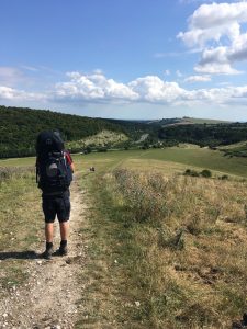
Our backpacking
We, on the other hand, didn’t want to make life too easy for ourselves, and instead opted for the most remote section of the trail, 5–7 days through the Gegham Mountains. After arriving in Yerevan, we had one day to get acclimatised to the country (and buy camping gas at one of the only two shops in the country selling it), and then set off on a marshrutka (Soviet-style minibus, the closest thing to long-distance public transport available) towards Lake Sevan. The weather forecast was looking questionable, with storms on the way for that evening, so we opted for one night in a guesthouse, and then the next morning we got a taxi up to a mountain pass to start our journey.
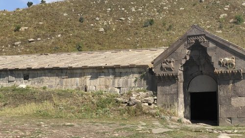
The caravanserai, built into the hillside
The route started at Orbelian’s Caravanserai, an ancient trading post for traders travelling on the Silk Road to rest with their animals. Nowadays it was falling apart a little, but the stone building was still imposing, and offered a cool shelter from the sun. I can only imagine the smell and noise there must have been when it was full of cows and their drivers. The building was at the top of a pass, and to the south we could see deep gorge-like valleys stretching into the distance.
Our route took us in the other direction, thankfully starting with much gentler gradients. On the first day we crossed lush green meadows, passing one farmer in the field, and later on a farmyard. We spent much of the day on 4×4 tracks: Armenians seem to have few qualms about driving wherever they want across the hills, regardless of the gradients. Towards the end of the day we reached a river to cross, and just before I waded across to test the depth, a Lada appeared out of nowhere and forded the river without a problem!
On the next day we had a little more ascent to deal with, but the main challenge of the day was the nomad camps. While there are no permanent roads or settlements on these mountain slopes, up at around 2500–3000 m above sea level, they are used by nomadic Yazidi people for grazing in the summer. They are not used to hikers, and their guard dogs can be rather aggressive! We learnt quickly after the first camp to keep a good distance away. The day finished at an old Soviet military base, providing an exceptional vantage point over the plains towards Turkey and Iran. Our tent felt rather overshadowed by the ruined stone buildings of the barracks!

Camping at the military base
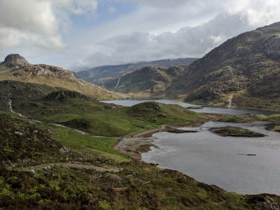
The third day started off by passing a couple more camps, and then we were on our own in a landscape that was becoming increasingly volcanic. The scale of it was hard to believe, with wide valleys that stretched on forever with hardly any sign of human interference at all, save for a 4×4 track through the grass here and there. The ground was littered with obsidian stones, making the hillsides glisten. This time we finished the day by dropping into a corrie to camp by a lake, making sure to get a lake bag in before dinner.
Day 4 had a surprise in store: we met our first other hikers in Armenia! We climbed up to Azhdahak, a volcano marking the highest point in Geghama, and as we got to the col just before the summit, we met a couple of Russian hikers ascending from the other side. A little while later, a Czech group with a local guide appeared too: while the thru-hike we were doing was rarely trekked, this one summit made for a (relatively) popular day-hike. Its popularity was understandable: there were incredible views in all directions, and the crater of the volcano itself offered a glistening blue lake. This wasn’t even the first time I had swum in a volcano (that would be the 2019 Iceland trip), but it’s a special experience!

The view from Azhdahak, over Red Ridge to Ararat, across the border in modern-day Turkey
From here we dropped down on the other side, and finished the day at another lake, which we were just about able to see in the distance from the summit. The route here involved a considerable detour to avoid a nomad camp marked in the trail notes as particularly unfriendly. This lake was another popular destination, with a caravan and cooking tent set up on one side. We set up camp a long way away from there, hoping to be undisturbed, but instead found ourselves right in the herding path of a flock of probably five hundred sheep, being led to water. Thankfully we managed to keep them far enough away from the tent that they didn’t start eating the guy lines, but it was rather unnerving!
The next morning, we were feeling fairly worn out of the camping, and our route had little to no ascent to get back to civilisation. That meant we turned it into rather a route march, covering 36 km and 1300 m of descent to get back into town that day. This has very much blurred into one in my memory, but there was a lot of walking through fields, past more volcanoes and nomad camps, and finally past some quarries and stoneworks before arriving in the village of Lchashen.
Exploring Armenia
We walked through the village of Lchashen, and got to the outskirts of the town of Sevan, on the lake of the same name. Here there was a restaurant, the Sevan Brewery, where we collapsed and enjoyed our first fresh food in days. We then opted for the closest guesthouse available, very glad to get clean and wash our clothes.
We spent two nights in Sevan, attempting to have a much-needed rest day, and still managing to walk almost 14 km to get to the monastery on Sevan Peninsula. Having barely seen anyone for days, it was definitely a shock to the system to see coachloads of tourists swarming around!
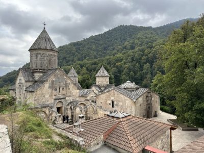
Gosh monastery, surrounded by thick forests
After Sevan came Dilijan – despite being barely 25 km away, it felt like another world, with thick green forests and permanent cloud. This is the hiking capital of Armenia, and it was a very pleasant change to see hiking signs pointing to various destinations from the town centre. After exploring the town on the first day (and getting soaked by rain, the first of the trip), we spent the next day trail running on properly built trails from Gosh monastery to an outdoor pursuits centre at Parz Lake. Before heading back to Yerevan on the day after that, we hiked around yet another monastery, and up through a farm to the hills above. This is where Cat finished her hike back in 2018, though now with rather better paths and signage!
A couple of nights in Yerevan followed, waiting for the storms to blow over, and then we headed to our next mountain of the trip: Aragats, the highest in Armenia. Our taxi driver took us up to 3200 m, on a road built for a cosmic ray research station, and we set up camp above Kari Lake next to it. From here we made it up the Southern and Western Peaks (3888 m and 4007 m respectively), opting to skip the Northern Peak (4090 m) as it was rather more technical. These peaks encircle a vast crater (500 m deep and 2 km across), blown open by past eruptions to form a valley off to the east. This valley formed our descent route, and after 2000 m of descent we made it to the village of Aragats, and checked in for the night at the only hotel, appropriately named Hotel Aragats.

The cosmic ray research station on Aragats
Exploring Georgia
It would have been a shame to come all the way to the Caucasus without joining it up with my previous trips, and so our next destination after getting back to Yerevan was Tbilisi, across the border in Georgia. This journey proved more challenging than expected: most of the public transport between the two cities took a route through Noyemberyan, close to the unfriendly border with Azerbaijan. The travel advice explicitly advises against going to this region, meaning our travel insurance would not have been valid here, so we had to search for quite some time to find a minibus taking a different route.
Once we’d made the journey, Tbilisi was a welcome sight, feeling very familiar after all these years. We were quick to seek out our favourite restaurants (namely Machakhela/Samikitno, and the Hinkali Factory). On previous visits to the city it had always felt like the city was far removed from the hiking that Georgia has to offer, but this time we took a bus to the nearby village of Kojori and had a very scenic hike up to an old fortress, and then back into the city.

The Altihut, Kazbegi
We still had a few days left in Georgia before it was time to fly home, and so we headed up to Stepantsminda, in Kazbegi National Park, by the border crossing with Russia. In 2021 we had only had time for a day trip here from the city, but this time we booked a hotel for a couple of nights, so we could explore the area further. This journey was also somewhat chaotic to organise, as the bus station was full of taxi drivers insisting that no marshrutkas existed, but eventually we found one. We spent our full day by walking up the ascent route towards Mount Kazbek, starting off at the Gergeti Trinity Church (packed with tourists) and then on emptier and emptier trails. Our high point of the day was the newly built Altihut: the first and only Swiss-style mountain hut in Georgia, and built to a very high standard. The prices were admittedly also Swiss, but we were very glad to warm up with a hot chocolate inside. From here we crossed over into the next side-valley, this one virtually devoid of other people, and made our way back down to the main valley.
Finally, we wrapped up our trip by returning to Tbilisi for one night, and then staying in Kutaisi before an early flight back home from Kutaisi Airport. As in Tbilisi, we were surprised how easily we were able to get out of the city for a walk through the hills overlooking Kutaisi.

The view of Mount Kazbek from Stepantsminda
Summary
The Caucasus is a spectacular region for hiking in, and this trip was no exception! I barely mentioned the food so far, but Georgian food is some of the best in the world, particularly if you’re a fan of bread and cheese. However, the trip didn’t come without its challenges, and it definitely takes some preparation before setting off there. In Armenia, most of the places we stayed spoke no English, and so I was glad that I’d spent the last three years learning Russian on Duolingo, so I was able to make myself understood, even if not able to have much of a conversation. In Georgia the levels of English were higher, but there were still some places where Russian (or some very rusty Georgian I could half-remember from past trips) came in handy. The hiking itself in the Gegham Mountains is also not easy, requiring a high degree of self-sufficiency to manage the 5+ days without resupply, and with uncertain water supply options.
If you’ve got any questions or you’re thinking of doing your own trip to the area, I’d be more than happy to help! I’m now living in Munich, Germany, and happy to host UBESters heading to this area of the world.
UBES love,
Charlie Harding (Insta: @xsanda)
For more details, I’ve written a full diary documenting the trip, which you can read here.