Join Jim and Max on: The West Highland Way
The West Highland Way 2022
Hey all, Max here! I recently completed The West Highland Way. It is a 96-mile trek, stretching from Milngavie just north of Glasgow to Fort William (the largest town in the Western Highlands). It was unveiled in 1980 and was the first Scottish National Trail, and is now considered one of Europe’s finest long-distance hikes. It is known for having incredibly varied scenery on each day as it stretches from the Lowlands to the base of Ben Nevis. I’d originally planned on undertaking it in 2021, but due to the lockdowns, I was unable to. I was determined to do it this year no matter what. I just thought I’d give you guys a summit of such an amazing trip that we had.
Day One (27km, 650m elevation gain):
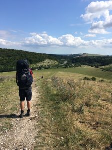
I set off from Bristol airport at 7:20 am on the 13thof April 2022. Arriving in Glasgow at 8:20 and getting the bus and train to the start point of Milngavie. Stocking up on gas for my stove and lunch for later in the day. From there I officially started the way. The first day of the hike is very easygoing as it’s mostly flat with very little elevation gain, despite the tedium of some sections (like a very flat field path that stretched for 9km) I was still incredibly excited to be out on the trail once again. Compared to The Two Moors Way, which was my last long-distance hike, this was set to be much more rewarding, inspiring and incredible.
From the farmer’s path, I entered Loch Lomond & The Trossachs national park, weaving my way through villages and country lanes. I stopped in the village of Drymen where I picked up a nice brew for the night’s camp, up by Conic Hill. Overall, this section had some nice views but was relatively dull compared to the days ahead. But I listened to a few chapters of the Stephen FryHarry Potter audiobook, which was lovely to listen to when the walking was mundane. However, nothing could have spoilt the freedom and independence I gained from being out on the trail.
I set up camp at 7 pm at the base of Conic Hill and soaked up the silence before getting a solid night’s sleep for the day ahead.
Day Two (29km, 760m elevation gain):
Arising from my tent to the soundtrack of wildlife, I looked upon a beautiful vista of rays of sunshine bouncing off the loch and the fresh morning cloud slowly creeping over Conic Hill, the first ascent of the day. Eager to get going and to see what the day had in store for me.
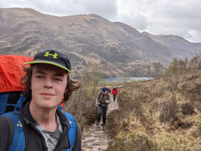
It was an easy ascent up to Conic Hill, but due to the rain the landscape saw through the night, the path was more of a stream. But undetermined I pressed on to finally get the first of the truly amazing views of the trip. From this point onward it felt like every single corner I turned, something amazing was waiting. From the top of the hill, I had huge panoramic views of the biggest body of freshwater anywhere in the UK, Loch Lomond. And the cloud line covering the top half of the Trossachs mountains on the other side of the Loch shore. From there it was a slow descent through beautiful woodland just north of Balmaha, where I planned on picking up breakfast. It was a nice little village with a glassy bay, where a statue of a Scottish icon and champion of the outdoor community stood, Tom Wier. It’s a tradition between West Highland Way walkers to take a photo with the statue as respect for his dedication to preserving and protecting the Scottish environment.
The walk from Balmaha was an easy-going loch-side dirt path but with a stunning vista on one side of the serene landscape that is Loch Lomond. However, the first half of the loch is a popular tourist destination, so I was rarely alone on the path. I met a variety of other hikers on the trail from all around the globe. The sense of community that this trail has is second to none, as we all are doing it for the same reason: to appreciate the raw beauty that is the Scottish Highlands. Compared to the everyday stresses of modern life and the hustle and bustle of the city, being out in the open air amongst trees, animals and the elements is something that I (and many others) seek. It gives you the chance to remember what really matters.
Approaching the small village of Rowardennan (16k into the day) I began to feel my muscles ache. It usually takes me a couple of days to become used to long days of constant walking so it was expected. I took a quick lunch break here and got talking to a lovely couple from Israel, they were doing a tour of the country and using Rowardennan as a base to go up the beautiful Ben Lomond, the highest peak in the Trossachs. We shared a few words of encouragement before I set off again for the final 13km of the day toward Inversnaid. From the village onward, there was no facilities or roads, so the trail became considerably quieter. Winding my way through evergreen plantations on the bonnie banks of the loch I don’t remember having a single thought for miles, almost as if I was in a meditative state.
It was a long and tough day and I arrived at my designated camp spot just in time before blisters fully began forming and instantly cooled my feet off in the freezing waters of the Loch. After that setting my tent up and chilling out for the night.
Day Three (21km, 740m elevation gain):
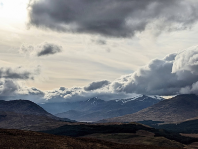
Today was a shorter day, but it included the second half of Loch Lomond (one of the harder sections of the trail). I spent the majority of the first hour scrambling my way over boulders, occasionally slipping when I didn’t pay attention enough. The rain that poured its way over the country made this section difficult as I risked slipping on multiple occasions, and since it was about5 metres above the loch shore, one slip and I would go for an unintentional plunge (as much as I needed it). But I managed to get to the northern side of the loch in a great time, taking one last look back on a lovely beach before I pressed on toward my lunch spot at Beinglas Farm Campsite about5km on from there. I took a moment to rest at the café as it was obvious that two continuous days of walking and the tough section were taking its toll on my energy levels. So, I had a fantastic hearty vegetable soup that came with a soft scotch roll and took that opportunity to breathe. FromBeinglas, it was only another 10k to the destination for the day, Crianlarich. The walk there unfortunately was incredibly overcast, with spots of rain and mist draping its way across the landscape like a blanket. But this section marked a change in the quality of the views by a massive degree, from here on out it was uninterrupted highland beauty as the peaks of Ben More and BenLui came into view, still with a thick layer of snow on their summits.
I reached the short descent into Crianlarich at about 4 pm, still with more than enough time to spare until I felt ready to head into civilisation. With no rush, I sat upon the hill gazing down upon the River Fillian and the peaks that lay beyond, with a chorus of birdsong emanating from the treeline behind me including the first cuckoos of the year.
In Crianlarich, I sat down in the charming Rod and Reel pub and had a well-deserved local cask ale and pub dinner. Absolutely bursting at the seams (and with the belt lengthened a couple notches) I headed toward the river to set up camp for the night. Where I would spend the morning after waiting for Jim to arrive by train in the morning.
Day Three, continued (560 Km, 10,600 metres elevation):
‘Wow, Max really caught a second wind today – really stepped it up’; you may be fooled into thinking that from my deceptive subheading, but unfortunately for your literary pleasure this is where my(Jim’s) journey has begun.
Unlike Max’s quite elegant quest, mine starts from a snot-ridden bed. I had just caught the flu and after 5 days of feeling particularly sorry for myself, decided it was time to join Max on his adventure. Mustering my energy and half the contents of a family glamping store, I embarked. First on the A1 flyer to Bristol Airport and then, after negotiations with Easyjet from an over-packed bag, onto the eight o’clock flight to Glasgow.
Glasgow Airport has many things but it’s fair to say that charm is not one of them…oh, and it’s not in Glasgow. I gathered my belongings and began my 40-minute descent into the ever-elegant paisley by foot. Here, I stayed at a suspiciously cheap hotel for the night (later in the evening, I would discover this to be a halfway house).
Day Four (14km, 330 elevation gain):
Waking up later than intended, I jogged down to Paisley station to take a short train to GlasgowCentral. Here I walked to Queens Street, to what I call, ‘properly begin my journey’. Despite my seductive descriptions of Glasgow so far, it’s fair to say that I wasn’t properly feeling wild yet. TheGlaswegians had been lovely, but I hadn’t quite found what I had travelled all this way for. The arrival in Queens Street changed this. All around me stood tall European hikers, each proudly sipping lightweight thermoses with an electric sense of purpose. Backpacks and people had become harmonious, and a buzzing enthusiasm swept the station as a rustic single-track train came to call. I piled in, throwing my admiralty far inferior rucksack onto the train. The train rattled through the contours of Loch Lomond, where in under 2 hours I had caught up with Max at Crainlarch.
Here my lack of planning became very apparent, before me stood a man packed for efficiency; lightweight trail shoes, a small ‘anti-gravity’ rucksack and a chipper smile. Looking back at him, I stood with the attire of a year six school trip student and half the contents of my shed. It’s fair to say that in the coming days I was going to regret my 20.4 kg rucksack ^[1].
The scenery was stunning and the setting of which I captured my first epic cinematography of the trip (sorry max but you choose the wrong time to have a wee).
The trail then descended in an out of dense woodland for the next few miles, exposing a variety of interesting fungi and crosscutting streams. If I had cared to look up from my feet, past the looming forest and through the low-hanging clouds- views of the epic peaks: Beinn Odhar, Ben Challumand Fiarach would have revealed themselves.
However, far more pressing matters concerned us, Loch nan Arm was fast-approaching. Where Rober the Brucefamously threw his sword, renouncing his claim to Scotland after his defeat to MacDougall’s in 1306. This I believed would be my opportunity to reclaim the sword and claim Scotland as my own. Unfortunately, this was not a sanctioned UBEStrip and it was not indeed ‘baggable’, I was soon distracted by the prospect of lunch. A trip to our final restock point of the Green Welly more than sufficed.
[1] Figures courtesy of Easyjet oversized luggage handler.
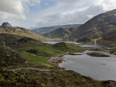
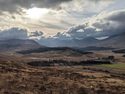
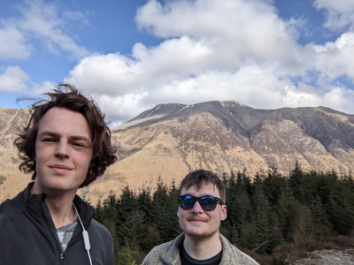
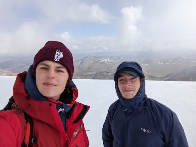
Leaving Tyndrum the forest cleared nicely to reveal some exciting geological features and our first glimpse of the mountains! Apparently, some of you like mountains so here’s a picture.
Dropping down into Inveroran we set up camp ready next to Loch Tulla. Filled myself with a large curry ready for what we expected to be the hardest day of the trip…
Day Five (28km distance, 800m elevation):
We knew from the offset this day was going to be a beast. From Inveroran the typical West Highland Way enthusiast would stop at the lovely Kingshouse in Glen Coe. This would be a good rest break before attempting the fittingly named ‘Devil’s Staircase’ the following day.
Knowing this trail would eventually finish in Fort William, I suggested we should attempt to do a double day and finish with an ascent of Ben Nevis. Considering Max had just done three extra days than me, he was awfully polite about my suggestion.
We began our trek out of Inveroran along an old military road across Black Mount Moor, a little slippery underfoot yet a significant upgrade to the surrounding bog. This definitely felt the most remote we got on this trip, no roads or shops for about 2 hours walk in any direction and certainly no signal. This wasn’t to say there was a lack of people here, the route was being used for an up-start motor-cross time trial. We met many lovely characters, including three Dutch women who offered to run up Ben Nevis with me. When I laughed, they assured me of their seriousness, with her friend telling me ‘oh she doesn’t think much of stuff like that’.
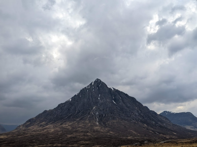 Anyway, back to the scenery! Before us was an awesome glacial valley with a series of deep-cutting rivers to unveil an assemblage of tributaries and lakes. To max’s dismay, it took me a good hour to shut up about the outcropping. We powered through this section nonetheless knowing arguably the highlight of the trip, Glen Coe, awaited us. Turning the corner into Glen Coe was a breathtaking moment. Photographs do not do this place justice. That is not to say we had a shortage of them, however, nor does anyone else, with Buachaille Etive Mòr being the most photographed mountain in the UK.
After a brief stop in Kingshouse, where we bid farewell to our travelling companions, we got ready to face the Devil Staircase. A 550-metre accent, taking place in under a Kilometre of point-to-point travel. My fitness was really put to the test here with the stupidly heavy bag and my recovery still taking place[2]. Max was very patient with me and within the hour we had finished. To say we finished gracefully may not be entirely true, we (mainly me) layed there on our backs in the rain for what felt like an hour, totally out of breath and with intentions to set up camp at that very stop and continue no further.
It was only about an extra 9km to Kim Lochhaven and with the promise of a cheap campsite by the river, home to a warm shower – We pressed onwards. Thankfully this was nearly all downhill and we were joined by a jolly Slovakian man who Max had met earlier on the trail. I would like to mention at this point he had managed this trail on a 5.4 Kg bag, a feat I still have not quite understood. This lovely forest walk took us through some of the largest hydroelectric stations I had ever seen, interwoven by wooden bridges over fast-flowing ravines.
We arrived at Kin Lochhaven around 9 pm, just in time to stock up on booze from the Co-op, Sit by the river on a bench with our stoves and cook some curry late into the night. It’s fair to say that we had no plans for an early start the next day.
Day Six (24.5km distance, 475m elevation):
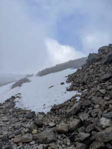
Today was the grand finale of the West Highland Way, although the stats of this day were frighteningly similar to the day before, the terrain and sentiment of the journey made it feel like no challenge at all. Leaving KinLochaven we passed through what I would regard as a very baggable River Leven and an awesome ice climbing centre. The first ascent started into the hills through a winding forest path with periodic escapes from the canopy, to views of Loch Leven and Mount Ballachulish.
The forest soon cleared into a valley with snow-tipped peaks and a single collapsed house standing alone amongst the wilderness. The returning military path was well trodden and made for some of the nicest walking of the trip. Listening to some of Max’s indie music he had produced was one of the most peaceful scenes of the whole trip. Few words were spoken and fewer pictures were taken. 10km of walking resolved itself in what felt like no time at all.
 Turning the corner into Glen Nevis we had Ben Nevis and Fort William in our sights. Setting our tents we left our rucksacks and the majority of our weight and headed down into Fort William. Knowing the route became progressively more urban we said goodbye to it.
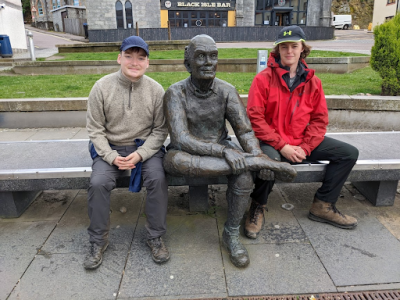 I would love to tell you about a fairy tale ending in Fort William and a lovely scenic finish. Yet it felt a little abrupt and touristy, with the trail having honestly finished about 5 miles before in Glen Nevis. The route has been very much extended for the purposes of tourist revenue. Scotland does however provide a perky drinking scene, and we soon found ourselves in spoons- requiring a taxi back to camp…
[2]A longer list of excuses can be provided over a pint at the Highbury.
Day Seven (17km, 1360m):
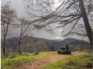
This day was by far my favourite and came with many unexpected twists. We woke up to a large porridge breakfast and coffee before heading to a local weatherboard. Reports so far suggested a cloudy day with light snow at the top, and no visibility. Approaching some locals we asked if we would need microspikes or crampons, they suggested neither, so we left them at camp.
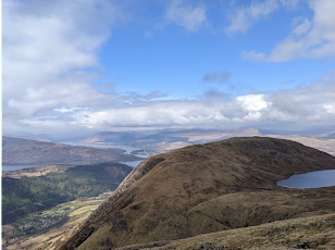
We started up a variation of the mountain track from the Glen Nevis camp. The track required some light work with your hands but like the Miners Track on Snowdon, which I’m sure most of you are familiar with, is otherwise excellently maintained and highly accessible. By lunchtime, we reached Lochan Meall an t-Suidhe, which was again highly baggable.
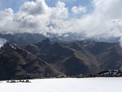
We saw the clouds rolling in as suggested by MWIS, and although happy with our attempt, we were a little sad that we would end our trip without a nice view.
Being compulsively English I have always felt it necessary to say hello to anyone I see on the mountain, swiftly followed by some pre-saved remark about the weather on any particular day. I do have to admit this became particularly challenging on Nevis as there were a lot of people and I was soon running out of different comments to make about the weather. A truly gruesome prospect. I did accidentally fumble my words to one person and say it will be sunny at the top, she said yes and kept walking. Both and Max laughed thinking she must have missed heard me(given this was our current view). ->>>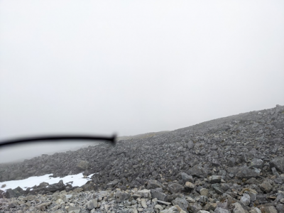
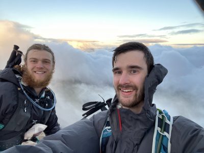
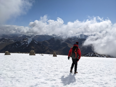
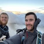
The accomplishment would honestly be enough for me, and more than enough for Max who had completed the whole of the WHH. What came next was our fairy tale ending.
The clouds were slowly parting. A strong gust of wind hit the hill as we climbed higher. The snow thickened. The landscape cycled between rolling white out and blue sky. Until the very final accent…
Conclusion: a fairytale adventure, open to an idiot.
If you’re like me you probably spend a lot of time contemplating whether to adventure or not. Each sneaky scroll on Instagram, conversation at the pub or lingering daydream gives us our daily ‘what if?’. If enough of these ‘what if’s’ are left to grow they quickly manifested into a ‘how if?’, ‘when if?’ and ‘where if? Unfortunately, this is where a lot of these curiosities come to die or fizzle out. Prior to the WHW I too often let these doubts get the better of me.
This trip was blessed with Max’s ever-organised spirit and a table-served opportunity ready to go for me, yet I believe the WHW does indeed lend itself for a brilliant first adventure. These ‘what, where’s and hows’ will work themselves out and to great reward. This route was safe and yet adventurous, some of the wildest I had been before and yet never too far from support. If you’re considering this trip yourself it’s super simple and as a measure of your enthusiasm to get this far, well with your capabilities.
UBES LOVE, Jim and Max
 Previous Post
 Next Post