Hiking the UK’s hardest trail
The Cape Wrath Trail, or CWT, is an almost 400km long-distance route from Fort William to the lighthouse at the most north-westerly point of Scotland, Cape Wrath. Along the way it passes countless incredible lochs, stunning glens, and some of the most beautiful and desolate terrain the UK has to offer… and hundreds of miles of bog. The CWT has gained a reputation as the hardest long-distance trail in the UK, although it is now a section of the Scottish National Trail so may have lost this title on a technicality.
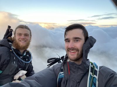
This blog post is the extremely delayed story of how Cat and I hiked the CWT in May 2019.
Planning for a long-distance hike
Planning for a hike is both my favourite and least favourite part of the process. It feels like an impossible task; there are so many unknowns when setting off that even nailing down the basics like how far you’ll be going each day becomes a game of wrestling with uncountable Hydraean variables that constantly shift and change. But it’s a place where experience quickly and tangibly makes the task much more manageable, and you can really feel how much you’ve learned.
We were lucky in this regard that we had a fixed amount of time to work with. We had to get back for Mendips 2! This left us with exactly 21 days to play with. While we still had to account for how many hiking and rest days we’d need, this was easily surmounted by guessing and hoping we’d be correct. Fortunately, the guidebook had the whole trip broken down into 15 stages, so we figured we’d just do a stage a day and have the rest for travel and resting.
This makes things sound very rosy, but apparently at this point it completely slipped our mind to check how long the stages actually were. On the walk, it turned out that many of them were designed to be broken into two days. Oops! It was okay at first, but towards the end we were having to walk 35–40 km a day for multiple days back to back in order to make our fated appointment with the most important party of the UBES year.
Linked inextricably to the problem of distance planning is food. Food is probably the most daunting part of planning. Even when you have an idea of what day looks like, how much do you eat in a day? What volume of cous-cous is that? How much more food do you need when you’re walking 30 km a day? We once again resorted to the old fashioned art of guessing, although in deference to not wanting to starve to death we added a bit extra which tuned out to be a good move in the end. In the end we both ended up going for 2400 kcal a day, with a roughly 800:800:800 split between breakfast, lunch, and dinner. Plus bonus snacks and cake. Like the true newbie I was at this point, I was completely panicking about food and had to ask Cat what she recommended, which is why we ended up going for the same plan.
Resupply is also a bit of an issue on the CWT. There are several sections that have 5–6 days without anywhere to buy food (or anywhere at all), which meant that we had to carry quite a lot of food at times. As a general ballpark, 500–600 g of food a day is about right (> 2000–2400 kcal, since most food is better than 400 kcal/100 g). Carrying 3 kg of food was not pleasant D:
While Cat initially wanted to bivvy, I thankfully managed to persuade her that a tent would be a good idea, because without it the midges would have been absolutely unbearable. I definitely wasn’t the paragon of good gear selection however, as I decided that trekking poles were just something that made you look silly and didn’t bring any.
The day to day experience
I can’t give a detailed day-to-day account of what it was like, because to be honest a lot of Scotland is windswept, desolate and boggy and the days have bled into each other. Plus I shouldn’t have waited a year to write this.
Some days stick out though.
The first day we had a nice easy 30 km day to get us warmed up, which would end at a nice glen where we could camp. However, this was a shame because it meant we would only have 10 km to go to get to the luxurious Corryhully bothy, which has working electricity. So we decided to just go there instead. Starting our hike with a 40 km day when we had both just spent months doing coursework was probably a bad idea in hindsight, but hey it makes a good story. Most of the people we met along the trail thought we were bonkers for doing this, apart from the trail runners of course, who we in turn thought were crazy. Since we’re all without much to do, I’ll recommend WRATH, a documentary about two people completing all 400 km in 7 days.
On the 3rd day of the trail we ran into a group who were running low on supplies. They had brought far more food than us per person, but had overestimated how much distance they would be able to cover. Even worse, one of them was a diabetic! Thankfully because of our ridiculous first day we’d managed to have a spare day or two of food, so we handed over all our remaining rations and just resolved that we were going to get to our resupply the day after or go hungry.
This proved to be a bad plan. That night it rained hugely, and when we tried to cross the Knoydart to get to Shiel Bridge we ran into the first of our river crossings. Cat again was the more experienced here, as I’d never had to cross something you couldn’t hop over. Thanks to the rain, the river was at knee height, and if you fell in then hypothermia would be a giant problem. And of course, we couldn’t wait for the river level to fall because we had no food.
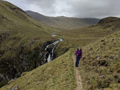
After a lot of fruitlessly wandering up and down trying to find a better place to cross, we decided to just go for it. Here is where not having poles bit me, since they’re lifesavers when crossing rivers as you get a lot of extra stability and something to prod and probe with. In the end I had to borrow one of Cat’s, and after taking off our trousers we managed to get across in one piece. This was by far the most nerve-wracking part of the trip since there was no safety-net. One slip here, doing something I’d never done before, and we’d have been in real trouble. It’s worth emphasizing again the remoteness here, it was frequently a days walk to the nearest road, let alone settlement.
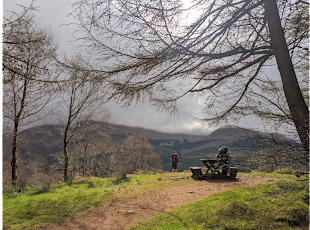
Thankfully later the cloud cleared a bit and we got a nice view
We had to cross another couple of rivers in the Knoydart, but thankfully they were lower and with some practise it was less daunting. Another thing that we ran into an issue with was the trail. Here was where we ran into problems with the navigation, since a lot of the CWT is unmarked. In hindsight the nav challenge wasn’t too bad, a lot like a normal UBES trip in the mountains. Low cloud meant we had almost no visibility and what was in theory a marked path we were aiming for in reality turned out to be a part of the rock-field with slightly fewer rocks. So just like always. The real issue was again the remoteness; we were soaked, cold and tired, we had few dry clothes and couldn’t change into them since we’d need them for the day after. No food meant we couldn’t even bail out, just had to keep going no matter what.
Having passed through Shiel Bridge and resupplied, we now faced our next challenge. Thanks to our fantastic decision on the first day, I had been having problems with my ankle. Even worse, Cat had a preexisting issue with her knee that had also flared up. Both of us were limping at this point, and it was only going to get worse. We had to make a decision since this was the last bail-out point for a while. Needless to say, Cat absolutely refused to give up. We downed a lot of ibuprofen and headed for the Falls of Glomach.
The Falls of Glomach aren’t the highest in the UK (that comes later), but they are absolutely spectacular. We were worried by this, as the trail had us descending the waterfall via what the guidebook described as a ‘treacherous’ path. We’d also heard dire warnings from other hikers that you shouldn’t even contemplate trying it in wet conditions, so in our imaginations it had morphed into a terrifying Grade 3 scramble. It turned out to be just a narrow path – albeit a very spectacular one – and was much safer than a lot of things we’d done. We learned a valuable lesson here: guidebooks tend to exaggerate in terms of difficulty, since danger sells.
Lots of exposure but basically fine
The day from Shiel Bridge felt like it was an eternity. I think it was 3 or 4 glens in total, and each one like a completely different place. We finally arrived at Maol-Buidhe (pronounced mal-booey) bothy to find out it had been renovated that winter, and featured a new wooden interior that was nicer than most student houses.
Bothies had proved to be the social hub of the trail; we almost never ran into anyone on the trail, but would arrive at bothies to find them full of other hikers. Maol-Buidhe was no different, with us meeting a lovely older couple called Suzie and Caroline. Conveniently this was also Cat’s birthday, so we had a nice little party for her.
For the next two days it absolutely bucketed with rain, and we were both also feeling very broken. We were contemplating waiting it out in a freezing stone bothy when a CWT hiker going in the other direction stopped by and told us there was now space at the infamous Gerry’s Hostel (now run by Gerry’s extremely grumpy son). We spent a day huddled by the fire there before heading into the Fisherfield deer forest. ‘Deer forest’ is a strange term – the name is a complete misnomer as there are absolutely no trees, and the deer are so shy you may never see them! In reality Fisherfield is the most beautiful empty Scottish wasteland. We couldn’t see any sign of human society at all, just untouched mountains in every direction. This day wasn’t our longest, but it felt like it. We were both so exhausted by the end that both of us had to rest before we could even walk up the stairs of the bothy.
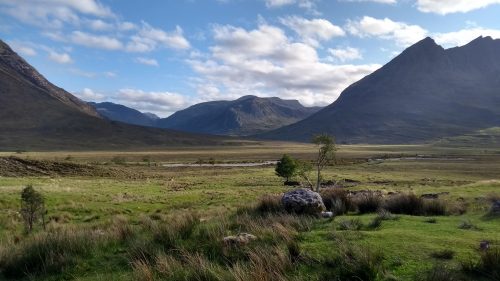
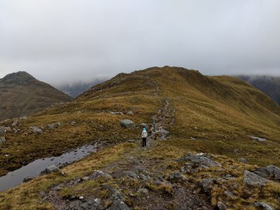
A beautiful but very long valley
After a brief stop off at Ullapool for some more food (and some poles for me) we went to Stornoway. Realising that we’d made our biggest nav mistake yet we decided to take one of our few remaining rest days, go and see the beautiful Mediterranean beaches of Harris, and continue the walk the day after.
After Ullapool we headed into Assynt, my personal favourite part of the trail. Assynt is less wild than Fisherfield, with the first day into it along a path by a fishing river, but I’d say it’s far more spectacular. The twin valleys of Glendhu were absolutely the highlight, ringed on every side by waterfalls (including the highest fall in the UK) with crags and boulders and every inch of it the prototypical Scottish highland experience. We spent the night at Glendhu bothy, after a happy reunion with Suzie and Caroline on a mountain pass! We got to the bothy before them and got the fire ready so we could all huddle round and dry off our soggy shoes.
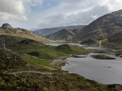
You’ve probably seen this before – I think it’s one of the prettier photos I’ve taken
After the highs come the lows. The day after Glendhu I was having stomach problems, and the weather had again turned for the worst. We just managed to make it over the hills in high wind and then dropped down to a windswept loch. We heard later that Suzie and Caroline had to turn back after starting out a little later than us – the gusts of wind made road crossings very dangerous! The rest of the day consisted of getting completely drenched while navigating through mile after mile of unmarked bog. I remember seeing open puddles that were at least 60 cm deep. Less than a kilometre from the relative civilization of Rhiconnich and the official end of the hard part of the trail, we encountered yet another swollen river. The shallowest part was mid-thigh on me (I had to take my pants off so that they didn’t get wet) and terrifyingly fast. To be honest we probably shouldn’t have tried to cross it, but we just couldn’t face being so close to a warm bed and having to camp out soaked in the rain. After this the B&B was like heaven, and the owner was a hiker so was very forgiving of us drying all of our clothes on every free surface.
With the hard work done, we now got our just rewards. Two days of illusive sunshine greeted us just in time for the end, with the stunning Sandwood bay our rest stop between. It was surreal being on a white-sanded beach after all the rain and bog and toil. The last day had a little bit of bog, just to remind us not to get too complacent, but allowed us a sunny afternoon gazing at the endless Atlantic Ocean in every direction. Even better, we managed to get a cheese and pickle sandwich at what has got to be the most remote café in the UK.
The CWT and me
The Cape Wrath trail was my first successful long distance trail, and when I look back the crazy thing is how accidental it was. This amazing experience happened not because of some grand plan for an adventure, but because Cat posted it on the forum and I thought “Yeah I’m free then… Why not?”. I’d tried to do things like this before, and was always disappointed when none of my friends wanted to do crazy things like this. It’s one of the underappreciated parts of UBES that just having loads of fantastic people around means that there’s almost always someone excited to come with you on adventures.
Speaking of people, I basically didn’t know Cat when I decided to go on this with her. We’d run into each other a few times since we were on the same course but I don’t think we ever really had a proper conversation. I’m not sure how reliable this is a plan, but it worked well with us because we both had similar attitudes for what we wanted out of the trip. I’m not sure what the moral of this story is; I think “Don’t be afraid to go on trips with people you don’t know because most UBESters are just amazing” but also “Probably meet up more than once beforehand”.
Long distance hiking is a weird bonding exercise. There’s no other activity where you get such deep friendships in such short times. It feels like you’ve known them for ages because you kinda have; I wonder how long you’d have to spend with a new friend casually before you got to the 500 hours of one on one time that the CWT was. For me this is the absolute best thing about long distance hiking, and experience you just can’t get anywhere else. This will come up again when I do the blog post for the Bosnia trip, but based on my current writing speed that’ll probably get done sometime in 2022.
UBES love,
Raef <3
 Previous Post